Jul 092018
 

Since I am still working on getting my deep space camera working, the PTO remains configured for planetary imaging. Over the past week, in between the clouds and fireworks, I’ve been able to get images of Jupiter, Saturn and Mars. The only one I could not get was Venus; the afternoon clouds would just not cooperate.

 
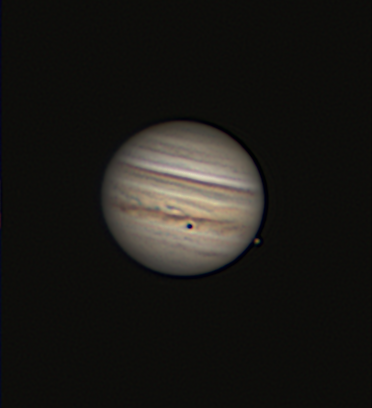
I was able to image Jupiter last night (8 Jul). It transits the meridian around 2030(L) so once the clouds cleared it was close to my western tree line. I imaged it right up to the time it was obscured by leaves. The obvious spot on the cloud tops is the shadow of the Jovian moon Io. The moon is just visible to the right of the planet as it starts to pass in front of the planet.
 
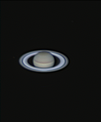
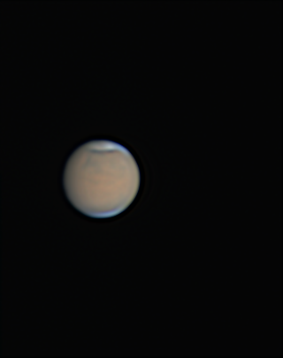
Saturn and Mars I imaged on the evening of the 4th once the flashing stopped and smoke of the fireworks cleared. This time there was no evidence of Saturn’s atmospheric storm. It may have dissipated or it may just be on the other side of the planet.

 
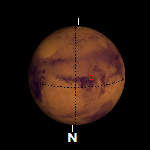
The map of Mars(r) shows the same central meridian as the image(l) and illustrates the surface markings that would normally be visible. Although recent atmospheric readings by the Curiosity rover indicates the dust storm may be starting to wind down, the planet wide dust storm is still obscuring our Earth based view. It may take some time for the dust to slowly settle out of the atmosphere. All the images are south at the top.

 Posted by at 20:10
Jul 012018
 

The large smooth circular area is Mare Crisium (Sea of Crises). The 345 mile wide impact basin is located on the eastern side of the Moon just north of the equator. The impact that formed the basin is estimated to have occurred 4.5 to 3.8 billion years ago. The surface lies a little more than a mile below lunar ‘sea level’. Samples of the mare were retrieved by the Soviet Union’s Luna 24 lander and returned to the Earth in 1976.
 

The largest non-lava filled crater in the mare is Picard. No, not that Picard. It is named for Jean-Félix Picard, a 17th French astronomer, priest and geodesist. He pioneered the method for measuring the right ascension of a celestial object by measuring the time it crosses the observer’s meridian. His method became the accepted standard.

Two other craters, this time lava filled, are Lick and Yerkes. Both named after American philanthropists involved with 19th century astronomy.

James Lick provided funds for the construction of Lick Observatory, the first permanently staffed mountain top observatory in the world.

Charles T. Yerkes provided the funds for the construction of Yerkes Observatory and the 40″ achromatic refracting telescope housed there. The telescope remains the largest refractor telescope ever used for scientific research.


The source video for this image was taken on the morning of June 30 just as the Sun was setting on the eastern edge of the mare. The image is the best 20% of 1801 frames taken at an average of 15 frames per second. The frames were analyzed and stacked using AutoStakkert 2 and wavelet sharpened by RegiStax 6.0. All the lunar images are south at the top.

 Posted by at 16:56
Jul 012018
 

This image, taken on the 20th of June, encompasses the area that appears to join two of the major ‘seas’ on the Moon. Toward the left is Mare Imbrium (Sea of Showers). Toward the right is Mare Serenitatis (Sea of Serenity). The line between the dark (nighttime) side and the bright (daytime) side is called the terminator.

Even though most of Mare Imbrium is deep in shadow, a couple of objects do stand out. The most prominent is the bright ‘T’ shaped object left of the terminator half way up from the image center. This is Mons Piton. The mountain’s peak at 8,366 feet is high enough that it is in sunlight while the surrounding terrain is still in the shadow of the Moon. Another object visible in the shadows is the eastern rim of the crater Archimedes. The crater is left of the terminator and slightly southwest of crater Autolycus. The rim is not as high as Mons Piton so there is less in the light.

One other object of note is right of the terminator in the mountainous region toward the bottom. It is a mountain labeled Mons Hadley. Left of the the peak down in the shadows is Hadley Rille. The sinuous rille is about 80 miles long and was the primary target of study by Apollo 15. The rille is just west of Falcon’s landing site. Astronauts David Scott and James Irwin spent 3 days in the vicinity of the rille. At the landing location the rille was estimated to be about 1,200 feet deep and roughly 3,200 feet across.

 Posted by at 12:34